Community
Golf & Recreation
Business North Carolina Features Moore County Golf in April 2024 Issue
In its April 2024 issue, Business North Carolina magazine features several articles about golf in Moore County, the Home of American Golf. In its...
Read More
Community
Golf & Recreation
New Highway Signs Recognize Moore County as Home of American Golf
New welcome signs now grace the north and south entrances to Moore County along U.S. 1, acknowledging the county as “The Home of American...
Read More
Accolades
Healthcare
FirstHealth Consistently Ranks as Top Hospital in NC
Year after year, FirstHealth of the Carolinas’ Moore Regional Hospital (MRH) consistently ranks as one of the best hospitals in North Carolina, and 2024...
Read More
Accolades
Community
Pinehurst-Southern Pines Micropolitan Ranked #1 in NC and #10 in U.S. for Economic Strength
[Pinehurst, NC] The Pinehurst-Southern Pines micropolitan not only maintained its position as the #1 micropolitan in North Carolina for the 7th year in a...
Read More
Community
Retail
Morganton Park South Shopping Center Closer to Opening
As work finishes for the new Carolina Green Parkway, anticipation grows for the opening of several large retail businesses in Morganton Park South. “It’s...
Read More
Community
Manufacturing
Moore County Seeing Record Number of Business Leads
The Moore County Economic Development Partnership (MCEDP) has seen a record number of businesses interested in coming to or expanding in Moore County over...
Read More
Community
2024 Grant Program to Elevate Black Entrepreneurship in NC
DURHAM, NC – February 15, 2024 – NC IDEA, a private foundation committed to supporting entrepreneurial ambition and economic empowerment in North Carolina, alongside...
Read More
Other
MCEDP’s Progress Report for Quarter Ended December 31, 2023
[Pinehurst, NC] Moore County Economic Development Partnership (MCEDP) recently released their Quarterly Progress Report highlighting their activities and initiatives in the areas of economic...
Read More
Community
Golf & Recreation
Manufacturing
Moore County: Seeing Green
In their February 2024 issue, Business North Carolina magazine featured Moore County in a special "Community Close-Up" section written by Kathy Blake. Moore County...
Read More
Accolades
Community
Pinehurst Ranked Most Popular Retirement Town in 2023
The Village of Pinehurst can now add another accolade to its resume: most popular retirement town. Pinehurst in Moore County — which will host...
Read More
Golf & Recreation
USGA Now Officially Residents of Pinehurst, NC
Completing a project that has been in the works since 2020, the United States Golf Association has officially moved into their completed building in...
Read More
Golf & Recreation
USGA Greenkeeper Program Graduates Inaugural Class
Experiential learning has been the core of the United States Golf Association’s groundbreaking Greenkeeper Apprenticeship Program (GAP) and local golf course maintenance leadership in...
Read More
Community
Manufacturing
Iron Horse Industrial Park Becomes a Reality
[Pinehurst, NC] – On November 30, the Moore County Economic Development Partnership (MCEDP) acquired a 73-acre parcel of land in Aberdeen that will contain...
Read More
Community
Manufacturing
Iron Horse Property Purchase Nearing Completion
A tract of land off N.C. 211 in Aberdeen has long been identified as a site for industrial development. The Moore County Economic Development...
Read More
Community
Retail
Moore County Chamber Grant Committee Awards $100,000 to Local Small Businesses and Non-Profits
SOUTHERN PINES, NC – Members of the Moore County Chamber of Commerce Grant Selection Committee recently distributed over $100,000 in grants to help downtown...
Read More
Other
MCEDP’s Progress Report For Quarter Ended September 30, 2023
[Pinehurst, NC] Moore County Economic Development Partnership (MCEDP) recently released their Quarterly Progress Report highlighting their activities and initiatives in the areas of economic...
Read More
Community
2023 Moore Entrepreneurial Summit on November 14th Will Inspire
[Pinehurst, NC] - The Moore County Economic Development Partnership (MCEDP) is proud to announce the upcoming 2023 Moore Entrepreneurial Summit. This must-attend event is...
Read More
Community
State Budget Includes $25 Million for New ‘Early College’ at SCC
This year's North Carolina budget includes a $25 million appropriation for an auxiliary high school on the campus of Sandhills Community College for vocational-track...
Read More
Accolades
Community
Healthcare
Moore Regional Named in 100 Top Hospitals® for Third Consecutive Year
PINEHURST─ FirstHealth Moore Regional Hospital, including its Hoke and Richmond campuses, was recognized today as one of the nation’s 100 Top Hospitals® according to...
Read More
Community
Manufacturing
Robbins Updates Ordinances for Industrial Purposes
Changes to the Town of Robbins’ Unified Development Ordinance approved by the town’s Board of Commissioners on 9/14/23 opens the door for more economic...
Read More
Other
MCEDP’s Progress Report of Economic Development Activities for Quarter Ended June 30, 2023
Moore County Economic Development Partnership (MCEDP) recently released their Quarterly Progress Report highlighting their activities and initiatives in the areas of economic development, community...
Read More
Healthcare
FirstHealth Moore Regional Hospital Ranked 5th Best Hospital in NC
FirstHealth Moore Regional Hospital, including its Hoke and Richmond campuses, has again been recognized as one of the top hospitals in North Carolina by...
Read More
Community
Moore County Seeing More Interest, Growth
Moore County has become a popular place to visit, live and do business. It ranked as the seventh fastest-growing county in the state in...
Read More
Community
County of Moore Launches Redesigned Website
The County of Moore recently launched its redesigned government website at www.moorecountync.gov. The new website is mobile-friendly, secured for user privacy protection, and makes...
Read More
Other
Hawkins Appointed to North Carolina Economic Development Association Board of Directors
On June 29th, Natalie Hawkins, President of the Moore County Economic Development Partnership (MCEDP), was appointed to the Board of Directors of the North...
Read More
Boomtowns: Moore County’s Tri-Cities Surging on Healthcare, Retail & Lots of Golf
ABC 11's Joel Brown interviewed MCEDP President Natalie Hawkins to gain insight into Moore County's thriving Tri-Cities area (Pinehurst, Southern Pines, and Aberdeen) as...
Read More
Community
Moore County Lowers Property Tax Rate
Moore County’s Board of Commissioners unanimously approved a fiscal year (FY) 2024 budget that includes a lower property tax rate. Commissioners said they wanted...
Read More
Community
Golf & Recreation
USGA, Pinehurst Preparing to Showcase Partnership
The 2024 Open will be a “home game” for the USGA. It will be Pinehurst’s fourth such championship since 1999 and the first with...
Read More
Manufacturing
$160,000 Building Reuse Grant Awarded to Help Robbins Manufacturer Expand
Governor Roy Cooper announced that the Town of Robbins has been awarded a $160,000 Building Reuse Grant approved by the N.C. Rural Infrastructure Authority...
Read More
Accolades
Community
Pinehurst-Southern Pines Micropolitan Ranked No. 1 in NC for Economic Strength Six Years in a Row
For the 6th year in a row, the Pinehurst-Southern Pines micropolitan tops POLICOM’s 2023 Economic Strength Rankings as the #1 micropolitan area in North...
Read More
Community
Manufacturing
Retail
Southern Pines Brewing Gets Underway on Expansion
The Buggy Factory, the latest expansion of the popular microbrewery Southern Pines Brewing Co., had its groundbreaking ceremony June 9th in downtown Carthage. Borrowing...
Read More
Community
Retail
Application Period Opens for Moore County Small Business Grant Program
The Moore County Chamber of Commerce is kicking off a $100,000 small business revitalization grant program in the summer of 2023 that will award...
Read More
Community
Paradise in the Pines Podcast Features MCEDP President
Hosted by the Pinehurst, Southern Pines, Aberdeen Area Convention & Visitors Bureau (CVB), Paradise in the Pines is a bi-monthly podcast highlighting the people,...
Read More
Other
MCEDP’s Progress Report of Economic Development Activities for Quarter Ended March 31, 2023
Moore County Economic Development Partnership (MCEDP) recently released their Quarterly Progress Report highlighting their activities and initiatives in the areas of economic development, community...
Read More
Other
Carolina Core Celebrates “Economic Development Week” & Regional Job Creation
The Carolina Core region and the Piedmont Triad Partnership are celebrating May 8-12, 2023 as “Economic Development Week.” During this week, communities across North America...
Read More
Other
Partners in Progress Launches New Name, Logo & Website
Moore County’s public/private partnership for county-wide economic development has a new name, Moore County Economic Development Partnership (MCEDP). Along with the name change, MCEDP...
Read More
Manufacturing
Reliance Packaging Plans to Expand
An Aberdeen company that takes tiny plastic pellets and creates packaging plans to expand its operations for the second time in the last six...
Read More
Other
PIP’s Progress Report of Economic Development Activities for Quarter Ended December 31, 2022
Moore County Partners in Progress (PIP) recently released their Quarterly Progress Report highlighting their activities and initiatives in the areas of economic development, community development, and...
Read More
Manufacturing
Other
County Commissioners Approve Loan Request for Iron Horse Industrial Site
Following a public hearing on February 21st, the Moore County Board of Commissioners agreed to loan $200,000 to Partners in Progress for further development...
Read More
Manufacturing
Bulldog Pipe Will Create a Second Manufacturing Facility in Aberdeen
After an exhaustive search, Bulldog Pipe has selected Aberdeen for its second manufacturing facility. Based in Mountain Grove, Missouri, Bulldog Pipe, LLC is a veteran- and...
Read More
Community
Golf & Recreation
Healthcare
Manufacturing
Retail
Moore County, Wrapped in Community Spirit
Business North Carolina magazine featured Moore County in a special “Community Close-Up” section in their February 2023 issue. The article, “Moore County, Wrapped in Community Spirit”,...
Read More
Manufacturing
Other
PIP’s Efforts to Acquire Iron Horse Industrial Site Move Forward
Natalie Hawkins, executive director of Moore County Partners in Progress (PIP), said her organization is working to acquire a portion of the Iron Horse industrial...
Read More
Manufacturing
Other
Robbins Explores Options for Developing Former Textile Plant Site
Located at the corner of Hemp and S. Kennedy streets, the old Milliken textile plant has long been at the center of Robbins, but...
Read More
Golf & Recreation
Whan Gives Update on Golf House Pinehurst Progress
Addressing an audience of elected leaders and government officials from across the Sandhills, U.S. Golf Association CEO Mike Whan was the keynote speaker for a dinner...
Read More
Community
Town of Carthage Awarded Rural Transformation Grant
Governor Roy Cooper recently announced the Town of Carthage has received a $350,000 Rural Transformation Grant to support the completion of the Town’s Downtown...
Read More
Manufacturing
Other
Aberdeen Board Supports Proposal to Prepare Industrial Iron Horse Property
The town of Aberdeen and Moore County are planning to ready 73 acres available in the Iron Horse Industrial Park in Aberdeen for development. The 128-acre Iron...
Read More
Golf & Recreation
USGA Tops Out Golf House Pinehurst Building
Event Marks Major Construction Milestone on North Carolina Campus PINEHURST, N.C. (January 20, 2023) – The USGA placed the final steel beam of its new Test...
Read More
Accolades
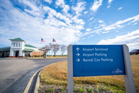
Other
Moore County Airport Ranks in Top 15 in Economic Impact in NC
The most recent annual economic impact for the Moore County Airport (KSOP) has increased to over $107 million, placing the airport in the top 15 of...
Read More
Golf & Recreation
Pinehurst Resort Announces 10th Golf Course
[caption id="attachment_2837" align="alignleft" width="300"] Future site of Pinehurst No. 10 (The Pilot, Pinehurst Resort)[/caption] Pinehurst Resort and Country Club recently announced that its property...
Read More
Community
Town of Vass Awarded $650,000 Rural Transformation Grant
Governor Roy Cooper recently announced the Town of Vass has received a $650,000 Rural Transformation Grant to build sidewalks that will connect Vass-Lakeview Elementary School...
Read More
Community
Retail
Carthage Century Committee Awards Grants to Downtown Businesses
The Carthage Century Committee recently awarded $24,500 in Carthage Downtown Revitalization Grants to eleven small businesses in the downtown area. These grants were made...
Read More
Community
Manufacturing
Economic Prospects Look Bright for Robbins
Economic prospects for the Town of Robbins are looking brighter for the new year. The Town is hoping to take advantage of grants from...
Read More
Accolades
Community
Top Ranking Affirms Moore County’s Economy is Consistently Strong and Growing
For the fifth consecutive year, the Pinehurst-Southern Pines micropolitan is the #1 micropolitan area in North Carolina, according to POLICOM’s 2022 Economic Strength rankings. For...
Read More
Community
Retail
Moore Miracles for the Holidays
Moore County recently received significant national news coverage due to the massive power outage that victimized the County earlier in December. However, much of...
Read More
Community
Retail
Shop Small / Shop Local This Holiday Season
Moore County is full of vibrant downtowns because of its business community. Whether it’s Broad Street in Southern Pines, Main Street in Aberdeen or...
Read More
Golf & Recreation
Other
USGA & Sandhills Community College Collaborate to Provide Greenkeeper Apprenticeship Program
[caption id="attachment_783" align="aligncenter" width="300"] Classes begin in January 2023[/caption] MOORE COUNTY, N.C. (Nov. 29, 2022) – Building on the recent announcement of Golf House Pinehurst and...
Read More
Community
Golf & Recreation
Other
Two New Unique Ways to Discover Moore County
360° Tour The Pinehurst, Southern Pines, Aberdeen Area Convention & Visitors Bureau (CVB) has announced the launch of the first of its kind virtual tour...
Read More
Other
PIP’s Progress Report of Economic Development Activities for Quarter Ended September 30, 2022
Moore County Partners in Progress (PIP) recently released their Quarterly Progress Report highlighting their activities and initiatives in the areas of economic development, community development, and...
Read More
Other
Retail
Moore 100 Hears About $80 Million Retail Project
The developer of a massive new mixed-use development spoke before a group of key Moore County business leaders on October 27th, outlining plans for...
Read More
Other
PIP Seeks Applicants for New Business Development Director Position
PARTNERS IN PROGRESS IS NO LONGER ACCEPTING RESUMES FOR THIS POSITION. Moore County Partners in Progress (PIP) is recruiting candidates for a newly created Business...
Read More
Community
Manufacturing
Moore County Celebrates National Manufacturing Day
In celebration of National Manufacturing Day on October 7, 2022, the Moore County Chamber of Commerce, Moore County Partners in Progress, and Sandhills Community...
Read More
Community
Other
Retail
Carthage Century Committee Receives $25,000 Duke Energy Foundation Grant for Small Businesses
The Carthage Century Committee recently received a $25,000 Hometown Revitalization Grant from the Duke Energy Foundation to support small businesses in downtown Carthage. Recognizing the tremendous value small businesses...
Read More
Accolades
Community
Other
Pinehurst & Southern Pines “Offer Nothing but Peace and Quiet?”
OnlyInYourState recently named Pinehurst and Southern Pines in its list of “10 Small Towns in North Carolina That Offer Nothing but Peace and Quiet”. While...
Read More
Manufacturing
Retail
Local Brewery Expanding into Historic Carthage Building
While much of the area surrounding downtown Carthage is in the midst of moving and groovin’, the downtown area itself has been in what seems a...
Read More
Manufacturing
Retail
Multimillion Dollar Expansion Underway for Southern Pines Brewing Company
From Triangle Business Journal: One of the largest craft brewers in North Carolina has its sights set on expansion, with two new locations close...
Read More
Community
Manufacturing
Other
NC Carolina Core Announcements Promise Ripple Effect
The unprecedented economic development announcements about Toyota Battery Manufacturing North Carolina (TBMNC) and VinFast locating in the NC Carolina Core mega site corridor north of Moore...
Read More
Other
PIP’s Progress Report of Economic Development Activities for Quarter Ended June 30, 2022
Moore County Partners in Progress (PIP) recently released their Quarterly Progress Report highlighting their activities and initiatives in the areas of economic development, community development, and...
Read More
Community
Other
Moore County Achieves Certified Entrepreneurial Community® Designation
Moore County Partners in Progress is pleased to announce Moore County has earned the designation of Certified Entrepreneurial Community®. “The Certified Entrepreneurial Community® (CEC®) designation...
Read More
Accolades
Community
Other
Retail
Moore County Sets Record in Visitor Spending
Moore County witnessed an unprecedented $673 million in economic impact from visitor spending in 2021, a 70 percent increase from the previous year. That...
Read More
Accolades
Healthcare
FirstHealth of the Carolinas is Ranked a Top Hospital
FirstHealth of the Carolinas, a private, not-for-profit health care network headquartered in Pinehurst, is an acclaimed cornerstone in Moore County that steadily draws many...
Read More
Healthcare
FirstHealth & Partners in Progress Host Successful Inaugural Innovation Summit
Recently, FirstHealth co-sponsored with Moore County Partners in Progress an Innovation Summit that also brought new people — 8 biotech companies from NC’s Triangle area —...
Read More
Golf & Recreation
World Golf Hall of Fame Returning to Pinehurst
As if the U.S. Golf Association hasn’t made a big enough mark locally with its recent Golf House Pinehurst groundbreaking and its landmark inaugural Adaptive Open...
Read More
Community
Carthage & Vass Selected for Rural Community Capacity Program
Vass and Carthage are taking steps to bring new opportunities for economic growth to their rural communities. The towns have both enrolled in the Rural Community Capacity program (RC2),...
Read More
Community
Manufacturing
Other
Golden LEAF SITE Program Will Focus on Potential Industrial Sites in Northern Moore
The Golden LEAF Foundation announced that Moore County is one of three (3) counties in the state selected to participate in the second round...
Read More
Golf & Recreation
U.S. Golf Association Breaks Ground on Golf House Pinehurst
USGA reveals design of engaging, innovative campus VILLAGE OF PINEHURST, N.C. (June 6, 2022) – The United States Golf Association officially broke ground Monday...
Read More
Other
Bridging the Talent Gap: Communitywide Employer Survey Launched
The Moore County Chamber of Commerce, Moore County Partners in Progress, Moore County Schools and Sandhills Community College are collaborating to gather input from...
Read More
Other
Progress Report of Economic Development Activities for Quarter Ended 3/31/22
Moore County Partners in Progress recently released their Quarterly Progress Report highlighting their activities and initiatives in the areas of economic development, community development,...
Read More
Community
Aberdeen & Carthage: Hotbeds for Residential Development
Anyone considering a move to Moore County will, in the very foreseeable future, have a lot more residential options to choose from. As other...
Read More
Community
Editorial: Sustainable Growth Takes Center Stage
Moore County, North Carolina has always been a desirable place to live, work, and play. Although it is well-known as the Home of American...
Read More
Community
Other
Local Planners Talk About Growth at Moore 100 Meeting
Planning directors shared details about the inner workings of development in Moore County at a panel meeting Wednesday at Pine Needles Lodge and Golf...
Read More
Manufacturing
Other
Good News for Iron Horse Industrial Park
It may have escaped notice from most folks, but a profound development for Moore County’s future economy occurred last week. The Iron Horse Industrial Park,...
Read More
Healthcare
New Medical Campus is Taking Shape
Through its ambitious Morganton Park Medical Campus in Southern Pines, Pinehurst Surgical Clinic (PSC) aims to create a healthcare legacy in Moore County. PSC’s...
Read More
Other
Veterans Guardian Expanding into Aberdeen
A Moore County business is looking to add dozens of new employees this year. Veterans Guardian VA Claim Consulting, based in Pinehurst, is a...
Read More
Manufacturing
Other
Aberdeen Awarded Site Development Grant for Industrial Park
The North Carolina Railroad Company (NCRR) announced yesterday that the Town of Aberdeen is one of six (6) recipients in the state to be awarded a...
Read More
Other
Quarterly Progress Report Highlights Economic Development Activities in Moore County
Since Natalie Hawkins took over the position of Executive Director of Moore County Partners in Progress Economic Development following the retirement of Pat Corso...
Read More
Community
Golf & Recreation
Healthcare
Other
Community Close-Up: Moore County – Improving Its Game
In their January 2022 issue, Business North Carolina magazine highlights Moore County in an article written by Kathy Blake that looks at several key influences, namely golf, health...
Read More
Community
Manufacturing
Other
Moore County Poised to Leverage Large Business Investments
Iron Horse Industrial Park, Aberdeen Towns like Aberdeen and Robbins might not be poised to land the next big automotive manufacturer, but Moore County’s...
Read More
Golf & Recreation
USGA Back-to-Back Championships Returning in 2029
The U.S. Golf Association will stage a second back-to-back pairing of its prestigious U.S. Open and Women’s Open in Pinehurst in 2029. “It’s the most frequent...
Read More
Manufacturing
Building Reuse Grant Awarded to Help Robbins Manufacturer Expand
[caption id="attachment_878" align="alignleft" width="300"] Hemp Street facility[/caption] Governor Roy Cooper announced that the Town of Robbins has been awarded a $74,000 Building Reuse Grant...
Read More
Other
FirstBancorp CEO Addresses Moore 100
Moore County has benefited from some of the economic and social trends that carried people through the COVID-19 pandemic. Golf is booming, small town...
Read More
Other
New Training Facility Helps Meet Workforce Needs in the Construction Industry
On October 19, 2021, Sandhills Community College (SCC) held a ribbon-cutting ceremony for its new Breakthrough Construction Center at the Larry Caddell Training Center located in Carthage. The...
Read More
Community
Other
Commitment to Expanding Broadband Access Countywide
The COVID-19 pandemic has made it even more evident that having access to broadband internet is absolutely essential for our everyday living. Residents without...
Read More
Healthcare
The “Foundation” of Moore County: FirstHealth Cancer Center
Easy access to innovative and state-of-the art health care is important to the quality of life in any community, but health care is particularly...
Read More
Healthcare
Other
The “Foundation” of Moore County: Foundation Hall
Easy access to innovative and state-of-the art health care is important to the quality of life in any community, but health care is particularly...
Read More
Community
Other
Executive Voice: She plays key role in Moore County’s transformation
Article by Evan Hoopfer, Triangle Business Journal) Natalie Hawkins vividly remembers the first time she visited Moore County. She was a graduate student at UNC-Chapel...
Read More
Accolades
Community
Always at the Top of the List
“Most Charming”, “Most Beautiful”, “Best”, “Top”, “Prettiest”, “Safest” – These are just a few of the adjectives often used to describe Moore County. For...
Read More
Golf & Recreation
Pinehurst Grants USGA ‘Golf House’ Rezoning
The U.S. Golf Association has secured a conditional rezoning allowing it to build its second headquarters planned off of Carolina Vista Drive in Pinehurst....
Read More
Community
Golf & Recreation
Healthcare
Other
Retail
Big Plans for Little River
Developer Blaine East shared new details about his ambitious plan for Little River Resort with the Carthage Board of Commissioners on Wednesday. The Apex...
Read More
Golf & Recreation
Pinehurst Planners OK USGA Proposal
Plans for the U.S. Golf Association’s second headquarters will move ahead to Pinehurst’s Village Council with the endorsement of Pinehurst’s planning and zoning board....
Read More
Community
Other
Editorial: A Bank Investment That Has Paid Off
The act of governments offering economic incentives to recruit new businesses to town is always a tricky thing. Everyone supports the jobs, the extra...
Read More
Community
Golf & Recreation
U.S. Kids Golf: Welcome to Moore County!
One of the annual events Moore County looks forward to each summer is the flood of young golfers from around the world, and their...
Read More
Golf & Recreation
Check Out The Cradle this Summer
So you love to play golf, but maybe you don’t have time to play 18 holes. Or maybe you aren’t particularly good at golf,...
Read More
Community
Golf & Recreation
Other
Top Ten Places in Moore County to Take a #SandhillsSelfie
What is a #SandhillsSelfie? It's a selfie taken in anywhere in Moore County, the heart of the Sandhills! Boasting an abundance of picturesque spaces...
Read More
Golf & Recreation
Other
Retail
The First Timer’s Guide to Pinehurst
Our area Convention & Visitors Bureau posted this great article written through the fresh eyes of someone who recently visited Moore County for the first time. ...
Read More
Accolades
Golf & Recreation
Top Marks for Golf Courses – Again
With the warm Spring weather, this time of year is a great time to play one of the many top-ranked golf courses in the...
Read More
Accolades
Golf & Recreation
Top Marks for Hospital – Again
If you have any strains or sprains after playing a round of golf or two, rest assured that you’ll receive the very best healthcare...
Read More
Other
Hawkins Named Executive Director of Partners in Progress
Natalie Dean Hawkins has been tapped to lead Moore County Partners in Progress, the county’s economic development arm. She will succeed outgoing executive director...
Read More
Other
Corso Receives The Order of the Long Leaf Pine Award
The Order of the Long Leaf Pine, one of the most prestigious awards conferred by the Governor of North Carolina, was presented on March...
Read More
Accolades
Community
Top Micropolitan in NC for 4th Consecutive Year
For the fourth consecutive year, the Pinehurst-Southern Pines micropolitan holds the top spot for micropolitan areas in North Carolina, according to the 2021 Economic Strength...
Read More
Community
Other
Hey Entrepreneurs, Come and Start Your Businesses in Moore County!
Buggy Factory building, Carthage This Moore Alive website is full of stories about talented local entrepreneurs who have found success in Moore County, such as Cameron Cruse of...
Read More
Manufacturing
Retail
Plans for Distillery Campus in Southern Pines
We’ve raved about Moore County’s dynamic craft brewery scene in previous articles as we are home to four microbreweries and a cider house, but we may...
Read More
Golf & Recreation
USGA’s Vision for Pinehurst Coming into Fuller View
Nestled between stands of longleaf pines and bustling traffic on N.C. 5, the future site of “Golf House Pinehurst” will soon take shape. Clearscapes,...
Read More
Other
Lessons from Charleston: PIP’s Moore 100 Hears from Visionary Civic Leader
Joe Riley, Mayor of Charleston, SC from 1975-2016, spoke to Partners in Progress’ Moore 100 group on February 11. During his time as Mayor,...
Read More
Community
Golf & Recreation
Healthcare
Community Close-up: Game on in Moore County
A special “Community Close-Up” section about Moore County is featured in the January 2021 issue of Business North Carolina magazine. “Game on in Moore County” talks about Moore...
Read More
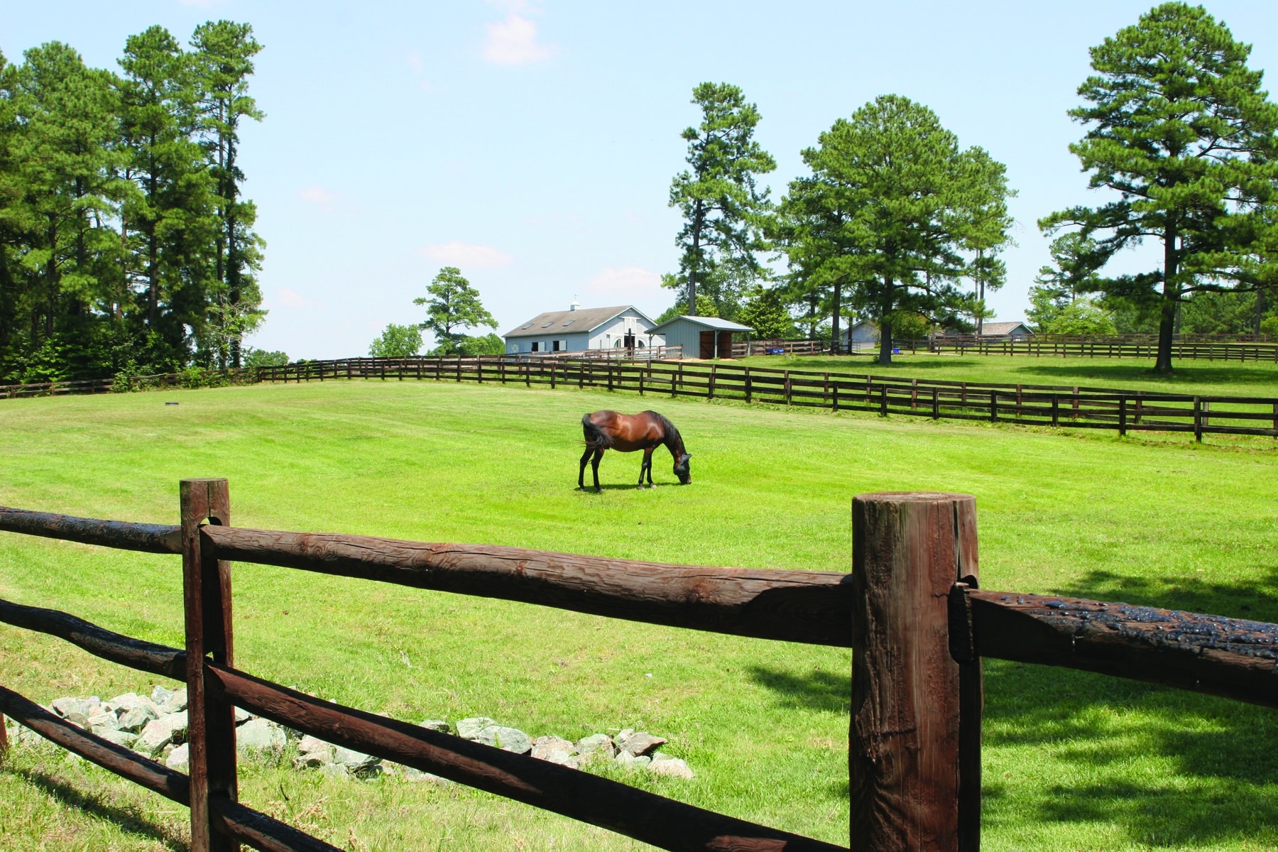
Community
Golf & Recreation
A Horse Lover’s Dream: 2021 Painted Ponies Art Walk & Auction
The Carolina Horse Park’s Painted Ponies Art Walk returns to Southern Pines from January 27 through March 30, 2021. In its second year as a fundraising...
Read More
Other
Feasibility Study Completed for Entrepreneurship Hub
The historic buggy factory building in Carthage is being eyed as a potential “entrepreneurial hub” that would serve as a one-stop shop for new...
Read More
Community
Retail
Tis the Season to Shop Small, Shop Local
As Moore County gets into the spirit of holiday shopping, the spirit of shopping locally to support our County’s businesses is growing. We all...
Read More
Golf & Recreation
Other
USGA Ready to “Blend In” to Pinehurst
Enthusiasm has run high since news broke in September that the U.S Golf Association would build a new second headquarters on the Pinehurst Resort and Country...
Read More
Golf & Recreation
Retail
Pinehurst Resort Has New Hotel in the Works
Plans for a United States Golf Association headquarters in Pinehurst are expected to come with a multi-million dollar influx of economic activity over the next 10...
Read More
Community
Golf & Recreation
Retail
A Local’s Guide to Pinehurst and Southern Pines
Check out this fantastic video, "A Local's Guide: Weekend Getaway in Pinehurst and Southern Pines", made through a partnership between Our State magazine and Berkshire Hathaway...
Read More
Healthcare
FirstHealth Gets Shoutout from Dr. Anthony Fauci
Residents in Moore County already know what a phenomenal hospital FirstHealth Moore Regional Hospital is and how fortunate we are to have a premier healthcare system...
Read More
Golf & Recreation
Golden LEAF Foundation Awards Funding to Support USGA’s Golf House Pinehurst
The Golden LEAF Foundation has awarded $200,000 to Moore County Partners in Progress to support the USGA’s project to establish Golf House Pinehurst. In early September, the USGA...
Read More
Healthcare
Planned Medical Campus Aims to Make Sandhills a Destination for Healthcare
(Article by Elizabeth Lincicome, North State Journal) It is unsurprising that even before the Coronavirus pandemic took hold North Carolina was ranked among one...
Read More
Other
Corso Named Chair as UNC Pembroke Elects New Board Leadership
Now more than ever, effective leadership is playing a pivotal role at college campuses across the country. This fall, long-time board member Pat Corso...
Read More
Golf & Recreation
USGA Names Pinehurst No. 2 its First “Anchor Site” for U.S. Open Championships
Pinehurst No. 2 has become the first anchor site for future U.S. Open championships, the United States Golf Association (USGA) announced earlier today. The masterpiece course...
Read More
Golf & Recreation
USGA Chooses Pinehurst for Second Headquarters
Just announced, the United States Golf Association has chosen the Village of Pinehurst for establishing a new second headquarters to be called Golf House Pinehurst. The...
Read More
Golf & Recreation
USGA Picks Pinehurst for Second Headquarters
The United States Golf Association will build a second headquarters in Pinehurst, to be called “Golf House Pinehurst”, under a multi-million incentive package approved...
Read More
Accolades
Community
Moore ‘Micropolitan’ is Tops in State Again
Moore County ranks in the top 10 percent in terms of economic strength for small economies nationally and holds the top spot for “micropolitan”...
Read More
Other
Veterans Guardian is Expanding Workforce Again
Veterans Guardian is expanding its workforce, again. The locally owned and operated company has been one of the area’s fastest growing businesses since it...
Read More
Community
Retail
Local Beer Helps Local Businesses – #TogetherWeAreMoore
Southern Pines Brewing Company’s newest release is more than just a pint of suds. Inspired by the ‘Together We Are Moore’ hashtag that encourages...
Read More
Community
Golf & Recreation
No Better Time to Enjoy Moore County’s Parks
Camelot playground at Cannon Park, Pinehurst Since the beginning of the pandemic, the outdoors is the one place that has never been off limits. ...
Read More
Community
Other
New Website Promotes Moore County
Elizabethtown, N.C. – North Carolina’s Southeast (NCSE), an economic development public-private partnership that markets an 18-county region, has launched a new marketing website www.ncse.org that promotes Moore...
Read More
Community
Other
Entrepreneurship Hub Could Be Key for Northern Moore County
Column by Pat Corso, Executive Director of Moore County Partners in Progress As we are all aware, there are numerous challenges to successful economic...
Read More
Community
Other
New, Unique Educational Opportunities Offered to Moore County
Moore County continuously supports diverse educational opportunities to serve students with varied educational needs and backgrounds. Residents are fortunate to have access to a...
Read More
Healthcare
Other
Moore County Favorably Positioned to Recruit Companies and Expand Medical-Related Industry Cluster
Peter Pellerito, a senior policy advisor with Biotechnology Innovation Organization (BIO), spoke to Partners in Progress’ Board of Directors at their June 9th meeting. ...
Read More
Retail
Optimistic News: New Restaurants Open / Expand
Everyone is aware of the hardships that the coronavirus pandemic has wrecked on the hospitality industry, particularly restaurants, across the nation, and it’s no...
Read More
Accolades
Healthcare
Moore Regional Hospital Ranks Among Safest Hospitals in the Nation
With the onset of the coronavirus pandemic in March, our attention was temporarily diverted from posting great stories about living in Moore County. Now...
Read More
Healthcare
Manufacturing
Meridian’s Innovation in Fight Against Pandemic
As more North Carolina businesses begin reopening, they face new challenges with how to keep staff and customers safe from the ongoing coronavirus threat....
Read More
Manufacturing
Manufacturer Fills Essential Role in Medical Textiles
The critical shortage of masks and other personal protective equipment needed by healthcare workers on the front lines of the COVID-19 fight has made...
Read More
Community
Other
Partners in Progress Awarded Grant for Entrepreneurship Hub Project
Senator Thom Tillis’ office announced that Moore County Partners in Progress has been awarded an $80,000 grant from the Economic Development Administration for Partners...
Read More
Other
Second New Elementary School Opening this Fall
While Pinehurst Elementary just had the groundbreaking ceremony for the construction already underway on their new campus, the new Aberdeen Elementary on NC Highway 5 is...
Read More
Other
Moore County’s Newest Public School Breaks Ground
School board members, county commissioners, other elected officials, and several classes of third graders recently celebrated the groundbreaking for Moore County’s newest public school. ...
Read More
Golf & Recreation
Retail
Love Movies? Two Venues
Moore County has 2 great venues for seeing movies – a multiplex that is newly-renovated and an arts center that has stood the test...
Read More
Golf & Recreation
Other
Pinehurst Area Makes Pitch for Golf Businesses to Relocate to NC
https://youtu.be/8Ep_GbsWlbQ Golf Leaders Inside the Home of American Golf Tout Business Advantages in Moore County Golf business leaders in the Pinehurst, Southern Pines and...
Read More
Community
Golf & Recreation
New Year Brings Opening of New Community Center
The Village of Pinehurst’s new $4.9 million Cannon Park Community Center is now open. “We are just happy to finally be here,” said Mark Wagner, the...
Read More
Golf & Recreation
Manufacturing
Other
Teeing Up More? County Sees Golf Pride HQ As Just the Beginning
Golf Pride is one of the nation’s most successful golfing-related brands. It’s also one of the oldest. Now serving its fifth-generation of golfers, the Pinehurst-based...
Read More
Other
Veterans Guardian Honored With HIREVets Gold Medallion Award
The United States Department of Labor has awarded Veterans Guardian the HIREVets Gold Medallion Award, the only federal-level veterans’ employment award that recognizes a...
Read More
Other
Agriculture is Diverse Growth Industry in Moore County
Agriculture is a profitable enterprise that makes up 20 percent of Moore County’s economic output. From historic cash crops like tobacco and peaches, to...
Read More
Community
Golf & Recreation
Sounds of the Season
Some may think that when you live in a smaller, more rural community, you are giving up many big-city amenities, especially cultural opportunities such...
Read More
Community
Retail
New Life in Aberdeen’s Downtown
[caption id="attachment_2342" align="alignleft" width="300"] Charlotte Williams, Leslie Habets, Betsy Saye on West Main Street, Aberdeen[/caption] The shops in downtown Aberdeen have more in common...
Read More
Retail
Pinehurst’s Better-Than-Ever Manor Inn Reopens
The top-to-bottom renovation of Manor Inn, the youngest of Pinehurst Resort’s three historic hotels, was recently completed, opening up 43 guest rooms. First opened in 1923...
Read More
Accolades
Other
Southern Pines Headquarters on Fortune’s Top 100 Fastest-Growing List
SOUTHERN PINES, N.C., Sept. 10, 2019 /PRNewswire/ — First Bank is one of Fortune’s Top 100 Fastest-Growing Companies for 2019. Coming in at number 49 on...
Read More
Healthcare
New Medical Complex Expands Moore County’s Healthcare Footprint
As Moore County’s largest private industry sector, healthcare is hugely important to the local economy, employing over 25% of our workforce. Residents are fortunate...
Read More
Other
Brand-new McDeeds Creek Elementary Opens for 2019-2020 School Year
As teachers finish making personal touches, the pristine McDeeds Creek Elementary on Camp Easter Road is all set to welcome students from kindergarten to 5th grade for...
Read More
Manufacturing
Other
Spartan Blades Expanding into New Pineland Cutlery Venture
Spartan Blades, headquartered in Southern Pines, is known in the knife industry for being a cut above the competition, crafting premium fixed and folding...
Read More
Community
Golf & Recreation
Revitalized Cardinal Park Reopens in Pinebluff
There is freshly poured white sand on the beach and nostalgia is in the air at Cardinal Park, a newly reopened recreational facility in Pinebluff...
Read More
Golf & Recreation
Wet n’ Wild: Splash Moore Opens
Beat the summer heat at Moore County’s new splash pad! “Splash Moore” is officially open at Hillcrest Park in Carthage! Now in the midst...
Read More
Community
Golf & Recreation
Let Freedom Ring! 2019 July 4th Festivities
Independence Day is a big deal and Moore County likes to celebrate it in a big way! Come out and enjoy these great events...
Read More
Community
Retail
Moore County’s Craft Beer Scene is Thriving!
Craft beer breweries are no longer found just in trendy urban areas. Moore County is plenty “hip” as the home of three and soon-to-be...
Read More
Golf & Recreation
Pine Needles to Host U.S. Senior Women’s Open
The many golf championships that continue to be hosted in the Home of American Golf™ are a testament not only to Moore County’s significant golf...
Read More
Community
Other
It’s Strawberry Season in the Sandhills!
A February warm up, a March cold snap and epic April rains did not bode well for strawberries, but despite the less-than-ideal weather, local...
Read More
Other
Meet Paul Murphy – Of Music & Ministry
On the heels of the article about the upcoming Epicenter music festival, music is also at the heart of resident Paul Murphy’s story. The Reverend...
Read More
Golf & Recreation
Other
Get Ready to Rock! Epicenter Festival 2019
In a little more than 60 days, the population of Rockingham in neighboring Richmond County will surge tenfold, from 9,558 to around 90,000 when Epicenter,...
Read More
Community
“Moving Forward Together”: Robbins is on the Rise
The inscription on Robbins’ roadside welcome sign says, “Moving Forward Together.” It’s a motivating phrase fitting for a town of 1,180 in northern Moore County....
Read More
Community
Other
Retail
A Tale of 3 Cities: Success Stories Show Countywide Entrepreneurship
Three business owners have succeeded in enterprises as diverse as the towns where they live. Business startups are vital in all sectors of Moore,...
Read More
Community
NC Carolina Core Initiative Includes Moore County
Moore County is a bit of an outlier when it comes to big picture economic development efforts across the state. There is no neat...
Read More
Other
New Revolving Loan Fund to Support Small Businesses
In January, the Sand Dollar Funds received an initial donation of $5,000 in seed money to create a revolving loan fund for the Moore County-based community...
Read More
Community
Moore County is Growing Younger
Like much of Moore County around it, Pinehurst Resort is becoming younger. “We’ve definitely noticed the shift in demographics in Moore County", says Tom...
Read More
Other
Fidelity Bank Planning Facility Expansions
Longtime local business in the community, Fidelity Bank, recently presented plans for their newly expanded facilities to the Southern Pines Town Council. Fidelity Bank...
Read More
Golf & Recreation
New Golf Pride Headquarters Nears Completion in Pinehurst
Work is nearly finished on the new Golf Pride building in Pinehurst, the village’s newest corporate resident. The company, a division of the international conglomerate Eaton...
Read More
Healthcare
Sandhills Pediatrics Planning Facility Expansions
Longtime local business in the community, Sandhills Pediatrics, recently presented plans for their newly expanded facilities to the Southern Pines Town Council. Sandhills Pediatrics is...
Read More
Other
Meet Jack McClelland – From Across the Pond to Moore County
From the land of the River Thames and Buckingham Palace, Jack McClelland, a native Londoner, has traveled far and wide (with golf clubs in...
Read More
Community
Project Santa: “There’s Just No Better Way to Spend Christmas”
Hearts are big and the Christmas spirit is strong when it comes to the Project Santa bicycle giveaway that takes place annually on Christmas...
Read More
Other
Second Lady Karen Pence Visits Moore County Company
Handsewn piece by piece, handbag by handbag, R. Riveter has grown from an attic-based business to the national stage in only a few short years. Karen...
Read More
Community
Other
PIP Supports Sales Tax Increase for Education in Moore County
Moore County Partners in Progress supports the upcoming voter referendum on the November 6th ballot that proposes to increase the local sales and use...
Read More
Community
Annual Vet Fest Celebrates Veterans
In its 7th year, the Sandhills Veterans Festival (aka “Vet Fest”) is an annual event held over several weekends to support our troops and honor our veterans...
Read More
Other
Meet Fallon Brewington: Ready to Make an Impact
Torn between the small-town yearnings of her youth in neighboring Richmond County and the up-tempo lifestyle of her collegiate, intern and early career days...
Read More
Community
Celebrating 20 Years of the Boys and Girls Club in Moore County
The African proverb says “it takes a village to raise a child” and not much can embody that proverb more than the Boys and Girls...
Read More
Community
Retail
Quintessentially Southern Southern Pines is Idyllic Weekend Getaway
I first visited Southern Pines when I was living in Lumberton, a town of about twenty thousand in rural Robeson County. My time as a reporter...
Read More
Manufacturing
Update: Pinehurst Brewery on Schedule to Open This Fall
The renovations of the 7,000 square-foot historic former Pinehurst steam plant are underway and taking shape to create the Pinehurst Brewing Company. Retaining as much...
Read More
Golf & Recreation
Moore County in International Spotlight as Annual Host to US Kids Golf
What just brought more than 1,500 golfers from all 50 states in the U.S. and more than 50 countries around the world to Pinehurst...
Read More
Other
NCDOC Secretary Tony Copeland Addresses Partners Board
Commerce Secretary Promotes Readiness for Jobs by Laura Douglass, The Pilot 8/7/18 North Carolina has three attributes that are well-known to all Japanese business executives:...
Read More
Community
Golf & Recreation
Summer Highlight: Farmer’s Day Festival in Robbins
One of the highlights of summer in Moore County is the annual Farmer's Day Festival held every August in downtown Robbins. 2018 marks the festival’s 63rd year (1955-2018)....
Read More
Community
Gov. Cooper Addresses Rural Economic Development Conference in Pinehurst
From The Pilot 7/12/18 by Laura Douglass, Staff Writer Gov. Roy Cooper visited Pinehurst on Thursday to kick off a two-day conference that brings together economic...
Read More
Community
Golf & Recreation
Local Culture: Summer Concert Series Are In Full Swing
How many counties do you know of that have 3 of its communities each offering a series of unique concerts during the summer? That might be more common...
Read More
Community
Golf & Recreation
Stars & Stripes: 2018 July 4th Celebrations
There is no shortage of patriotic spirit in Moore County! Lots of fun family festivities are planned in our communities to celebrate Independence Day...
Read More
Accolades
Community
2018 “Best Places”: Aberdeen Ranked as a Best Place for Millennials
Our Moore Alive website is chocked full of articles highlighting various “best of” rankings and accolades that Moore County's communities, hospital, golf courses, and other...
Read More
Other
NCDOT Secretary Jim Trogdon Addresses Partners Board
From The Pilot 6/5/18 by Laura Douglass, Staff Writer Cars are becoming more fuel-efficient and there are more electric and hybrid options available. This is good...
Read More
Golf & Recreation
Pine Needles to Host 4th U.S. Women’s Open in 2022
Pine Needles Lodge & Golf Club in Southern Pines has been selected by the USGA as the host site for the 77th U.S. Women’s Open in 2022. ...
Read More
Community
Other
Better Schools for Moore County’s Future Generations
Voters showed their overwhelming support for better school facilities and educational opportunities in Moore County by approving a $123 million bond referendum for Moore...
Read More
Community
Other
Opportunity Zone Designation to Stimulate Investment in Town of Robbins
Update: On May 18, 2018, the U.S. Treasury officially certified Census Tract 9502 as an Opportunity Zone. It is now one of 252 low-income census...
Read More
Manufacturing
Other
Meet Micah Niebauer & Jason Ginos: Veterans, Entrepreneurs & Local Brewmasters
Their story involves growing up in the Midwest, brewing in the backyard, basic training, jumping out of airplanes, and today running a thriving brewery...
Read More
Accolades
Community
“Economic Strength” Ranking Attests to Moore County’s Exceptional Quality of Life
In the 2018 Economic Strength Rankings just released by POLICOM, Inc., the Pinehurst-Southern Pines micropolitan statistical area (MSA) ranks extremely high on the national...
Read More
Accolades
Community
Economic Strength Ranking Affirms Moore County as an Exceptional Location for Business & Industry
In the 2018 Economic Strength Rankings just released by POLICOM, Inc., the Pinehurst-Southern Pines micropolitan statistical area (MSA) places extremely high on the national...
Read More
Accolades
Healthcare
Moore County Among Top 25 Healthiest Counties in NC
It does not come as a surprise that Moore County ranks as one of the top 25 healthiest counties in North Carolina according to...
Read More
Accolades
Community
Healthcare
Top Hospital & Best Places to Retire Rankings Go Hand-in-Hand
One of Moore County’s most prized assets is our local community hospital, Moore Regional Hospital (MRH), the heart of the FirstHealth of the Carolinas healthcare system...
Read More
Manufacturing
Other
Retail
Microbrewery Coming to Pinehurst
Pinehurst Resort has announced their plans to open a new microbrewery and pub restaurant in late spring 2018. They have already begun restoring the 7,000...
Read More
Other
Meet Jason Howk – 2nd Career Unveiled in Moore County
Jason and Michelle Howk are no strangers to Moore County, but they never realized that they would retire here. After Jason’s 15 years of...
Read More
Community
Celebrating 50 Years of United Way in Moore County
2018 marks the United Way of Moore County’s half-century of service to the area’s local communities. “I’m very excited to celebrate the 50th year of...
Read More
Other
Meet Helena Wallin-Miller – A “Connected” Leader
Thinking back, it was more than a dozen years ago now. Neither she nor her husband played golf. They were not an equestrian family....
Read More
Manufacturing
Reliance Packaging Expands Operations in Aberdeen
A five-story tall investment in technology will allow an Aberdeen-based manufacturer to double its production capacity in the coming year. “We are adding staff,...
Read More
Manufacturing
Other
Spiritus Systems Doubling Size of Aberdeen Facility
Two guys in the field were disappointed their gear wasn’t up to the hardworking standards their dangerous jobs demanded. Frustration begat inspiration and they...
Read More
Accolades
Community
Other
Moore County Economic Development Strategic Plan Presented
Leaders Support New Moore County Economic Plan From The Pilot 12/8/17 by Laura Douglass, Staff Writer The health care and hospitality industries are key...
Read More
Golf & Recreation
Golf Pride’s “Global Innovation Campus” Locating in Pinehurst
Golf Pride, a division of the international conglomerate Eaton Corp and the golf industry’s largest manufacturer of golf club grips, is building an $8...
Read More
Manufacturing
Minhas Furniture Relocating Operations to Robbins
From The Pilot 10/18/17: What is old will be new again when Flair Enterprises relocates its North Carolina upholstery factory to the former Klaussner Home...
Read More
Other
Sandhills AGInnovation Center Opens for Farmers & Produce Buyers
From The Pilot 8/31/17 [caption id="attachment_1008" align="alignleft" width="300"] Davon Goodwin, Paige Burns, & Susan Kelly[/caption] An agricultural harvest of a different sort has borne fruit in...
Read More
Other
Discovery Phase I Completed on Countywide Strategic Plan
What is the best way to take advantage of the dynamic changes that are underway while maintaining the area’s charm and quality of life?...
Read More
Why Moore County
From our coveted location in central North Carolina to our impressive schools and job-ready workforce, there are countless reasons to choose Moore County for your business and home.

Quality of Life
Safe communities, first-rate healthcare and a wide range of recreation and cultural opportunities are just a few of the offerings that make Moore County an exceptional place to live.

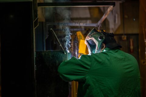
Business Climate
Innovation, collaboration and a low cost of doing business create a business climate in Moore County that encourages growth and success.
Workforce & Education
Our outstanding educational institutions and customized workforce training programs support the development of a skilled and diverse workforce.